
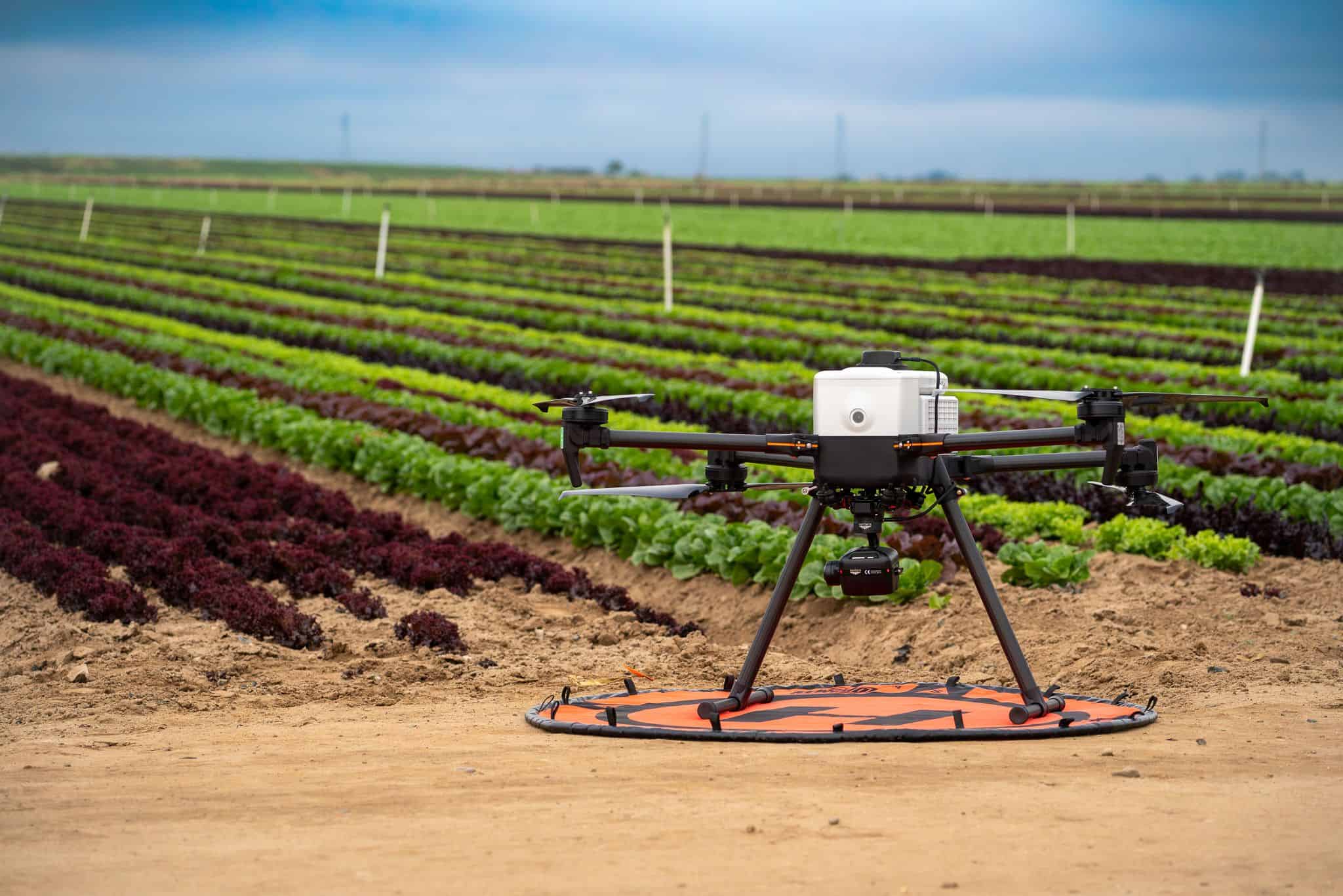
The Blue Eye Sensor Drone: Revolutionizing Smart Irrigation for Customized Water Management and Enhanced Crop Yields
Amid rising climate variability, water shortages, and the need for sustainable food production, innovative technologies are transforming agriculture. The Blue Eye Sensor Drone, an advanced unmanned aerial vehicle (UAV) equipped with multispectral and thermal sensors, is leading the charge in smart irrigation. This drone enables precise, customized monitoring of water usage across fields, optimizing irrigation to improve water efficiency, crop quality, and yields by 15–30% based on recent North American research. Developed through collaborations inspired by studies at universities in Canada and the United States, the Blue Eye integrates AI-driven remote sensing to deliver actionable insights for precision agriculture.
The Need for Advanced Smart Irrigation Technologies
Global agriculture accounts for about 70% of freshwater withdrawals, with inefficient practices causing significant losses through evaporation, runoff, and uneven distribution. Conventional irrigation methods apply water uniformly, overlooking variations in soil moisture, plant needs, and topography. This leads to waste, environmental degradation, and suboptimal yields, especially in water-stressed areas like Canada’s Prairies and the U.S. Corn Belt.
Smart irrigation systems address these issues by using data from sensors, IoT devices, and AI to apply water precisely. The North American smart irrigation market is projected to expand rapidly, driven by UAV integrations that provide high-resolution aerial data. Drones excel at mapping evapotranspiration (ET), detecting water stress, and enabling variable-rate irrigation, potentially reducing water use by 20–40% while boosting productivity.
The Blue Eye Sensor Drone enhances this approach with its specialized “blue-eye” sensitivity to water absorption spectra, combined with thermal imaging for comprehensive stress detection.
Technology Behind the Blue Eye Drone
The Blue Eye is a robust quadcopter platform capable of covering large areas efficiently. Its key sensors include:
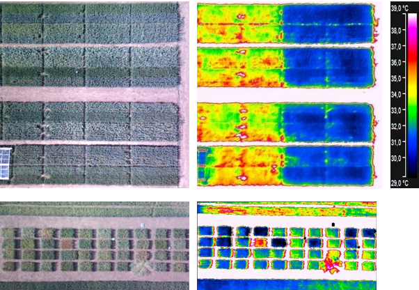
•Multispectral Cameras: Capture data in multiple bands (e.g., blue, green, red, red-edge, near-infrared) to compute indices like Normalized Difference Water Index (NDWI) and Normalized Difference Vegetation Index (NDVI) for assessing canopy water content and vegetation health.
•Thermal Infrared Sensors: Measure canopy temperature to calculate the Crop Water Stress Index (CWSI), identifying stress through elevated temperatures before visible symptoms appear.
Onboard AI processes data in real-time, fusing multispectral and thermal inputs with machine learning models (e.g., Random Forest or neural networks) for accurate stress mapping. Outputs include color-coded heatmaps prescribing customized irrigation zones.
This hybrid approach overcomes limitations of single-sensor systems, providing reliable ET estimates and stress detection even in variable conditions.
Insights from North American University Research
Recent studies in Canada underscore the potential of drone-based multispectral and thermal sensing for irrigation optimization.
Engineering the Blue Eye: Sensor Fusion and AI Integration
At its core, the Blue Eye Drone is a quadcopter platform (e.g., modified DJI Matrice 300 RTK) weighing under 10 kg, with a flight endurance of 45 minutes and a coverage radius of 50 hectares per sortie. Its payload includes:
•Multispectral Sensors: Devices like the Mica Sense RedEdge-P capture data across five bands (blue, green, red, red edge, near-infrared), computing indices such as the Normalized Difference Water Index (NDWI) and Normalized Multiband Drought Index (NMDI). These quantify canopy water content, revealing deficits as low as 5%.
•Thermal Infrared Sensors: FLIR Vue Pro R cameras (8–14 μm) measure canopy temperature differentials, feeding into the Crop Water Stress Index (CWSI). Elevated temperatures signal stress, triggering alerts for immediate intervention.
•Hyperspectral Add-ons: Optional Cubert ULTRIS modules provide 125 narrow bands for precise soil moisture inversion, even under partial cloud cover.
Data streams to an onboard NVIDIA Jetson edge computer, where machine learning models—trained on datasets from over 1,000 field scans—process inputs in real-time. Random Forest (RF) and Convolutional Neural Networks (CNNs) classify stress zones with 92% accuracy, outperforming traditional VI methods by integrating terrain, weather, and historical yield data. Outputs are visualized via a mobile app, prescribing irrigation rates (e.g., 10–30 mm/ha) tailored to crop type, growth stage, and soil type.
This sensor fusion addresses key limitations of standalone systems: multispectral alone misses subsurface moisture, while thermal overlooks nutrient interactions. Hybrid modeling—combining physical radiative transfer (e.g., PROSAIL) with data-driven AI—enhances robustness, as validated in 2024 simulations showing 15% better ET predictions.
Groundbreaking Research from Canadian
The Blue Eye’s evolution stems from collaborative efforts at premier institutions, where 2023–2025 studies have laid the empirical groundwork.
University of Guelph, Canada: From Stress Detection to Yield Forecasting
At the University of Guelph’s Ontario Agricultural College (OAC), researchers under Dr. Milad Eskandari have pioneered drone applications for soybean and corn monitoring since 2023. In a three-year Alliance-funded project, UAVs scanned test plots for plant stress indicators, including water deficits linked to soybean cyst nematodes. Using NDVI and thermal data, the team achieved 85% accuracy in identifying water-stressed zones, correlating them to yield losses of 10–20%.
A 2024 extension integrated AI for predictive modeling: drones flew weekly over 200-ha fields in Ontario, generating ET maps that reduced irrigation by 28% while boosting soybean yields by 12% (from 3.2 to 3.6 t/ha). “Drones like the Blue Eye prototype allow us to shift from reactive to proactive irrigation,” Eskandari notes. “By customizing water delivery, we not only conserve resources but enhance root health and nutrient uptake, directly impacting quality.”
This work aligns with Canada’s digital agriculture push, as outlined in the 2025 CAPI report, which cites smart irrigation drones reducing water use by 30% in Alberta’s drylands. Guelph’s contributions extend to the Institute national de la recherche scient fique (INRS) in Quebec, whose 2024 review of drones in precision agriculture emphasizes TIR for irrigation in cold climates, where frost exacerbates water stress.
Practical Use and Expanded Benefits
Implementing the Blue Eye Drone is straightforward for farmers and agronomists:
1.Planning Flights: Schedule automated or manual flights over fields (e.g., weekly during critical growth stages) using GPS waypoints for consistent coverage.
2.Data Capture: The drone flies at optimal altitudes (50–100 meters), collecting multispectral and thermal images in minutes over hundreds of hectares.
3.Processing and Analysis: Data uploads to cloud-based software or a mobile app, where AI generates intuitive maps (e.g., stress zones in red/yellow/green).
4.Integration with Irrigation Systems: Connect to variable-rate controllers (e.g., center pivots or drip lines) for automatic adjustments—delivering more water to stressed areas and less to saturated ones.
5.Decision-Making: Receive alerts for immediate action, track trends over seasons, and integrate with weather forecasts for predictive scheduling.
Key Benefits:
•Customized Water Usage: Zone-specific application reduces overall consumption by 20–40%, minimizing waste and preventing over/under-watering.
•Improved Irrigation Quality: Precise delivery preserves soil health, reduces runoff/leaching, and enhances nutrient uptake—leading to uniform crop growth and higher-quality produce (e.g., better grain protein or fruit uniformity).
•Yield Boost: Studies show 10–30% increases through timely stress mitigation, with healthier plants resisting pests/diseases better.
•Sustainability and Cost Savings: Lower water/energy bills, reduced environmental impact, and quick ROI (often within 1–2 seasons) via grants or efficiency gains.
•Scalability: Suitable for small farms (manual operation) to large operations (swarm fleets), with user-friendly apps democratizing access.
Challenges like initial costs and regulations are offset by falling drone prices and supportive policies.
Challenges and Future Outlook
While promising, adoption faces barriers such as equipment costs, data interpretation skills, and regulatory compliance. Ongoing research focuses on affordable sensors, improved AI for diverse crops/climates, and integration with ground/IoT systems.
Conclusion
The Blue Eye Sensor Drone represents a pivotal advancement in precision agriculture, harnessing multispectral and thermal technologies to enable truly customized irrigation. Backed by robust North American research demonstrating significant water savings, quality enhancements, and yield gains, this tool empowers farmers to navigate water scarcity while feeding a growing population sustainably. As drone adoption accelerates, innovations like the Blue Eye will drive resilient, efficient farming, turning data into droplets that maximize every resource.
References
•Belton, B., et al. (2025). Agricultural drones reshaping farming. Science. https://msutoday.msu.edu/news/2025/11/agricultural-drones-are-reshaping-farming
•University of Guelph collaborations with XAG drones (2021–ongoing). https://www.xa.com/en/news/official/xag/140
•Systematic review on UAV thermal remote sensing for crop water status (2024). https://www.tandfonline.com/doi/full/10.1080/01431161.2024.2368933
•Robust model for water stress diagnosis using UAV multispectral/thermal data (2023). https://www.sciencedirect.com/science/article/pii/S037837742300481X
•UAV multispectral/thermal for winter wheat water stress and yield (2025). https://link.springer.com/article/10.1007/s11119-025-10239-z
•Review of UAV remote sensing for water stress in specialty crops (2025). https://www.mdpi.com/2504-446X/9/4/241